Real-World Dimensions
to CAD-Ready.
Real-World Dimensions
to CAD-Ready.
Transforming real-world measurements into CAD-ready data, designed for modern design-to-build workflows.
Compatible with Major Design Applications


"AI-powered workflows reduced error rate by 80% in daily operations"
InovaMetrics combines LiDAR-based capture with AI-driven algorithms to translate real spaces into structured spatial data—built for professional design and build workflows.
Impact :
Full-room capture in minutes
AI-structured geometry output
Reduced manual measurement work
"Live scan preview during capture"
Scan and validate spatial completeness in real time—before leaving the site.
Impact :
Live spatial reconstruction
Fewer missed dimensions
Less back-and-forth site checkinging or ambiguous details
"Explore the captured space before leaving the site"
After scanning, you can move through the space virtually to inspect corners, connections, and constraints, and confirm key dimensions visually.
Impact :
Reduced site revisits by 25–50%
Faster issue detection
More confidence before drafting

"Review, adjust, and export with confidence"
A clean interface lets you compare scan data with CAD references, make final adjustments, and export more reliable CAD outputs.
Impact :
20–40% fewer CAD revisions after initial delivery
2x faster CAD-ready preparation time
More predictable output quality
"AI-powered workflows reduced error rate by 80% in daily operations"
InovaMetrics combines LiDAR-based capture with AI-driven algorithms to translate real spaces into structured spatial data—built for professional design and build workflows.
Impact :
Full-room capture in minutes
AI-structured geometry output
Reduced manual measurement work
"Live scan preview during capture"
Scan and validate spatial completeness in real time—before leaving the site.
Impact :
Live spatial reconstruction
Fewer missed dimensions
Less back-and-forth site checkinging or ambiguous details
"Explore the captured space before leaving the site"
After scanning, you can move through the space virtually to inspect corners, connections, and constraints, and confirm key dimensions visually.
Impact :
Reduced site revisits by 25–50%
Faster issue detection
More confidence before drafting
"Review, adjust, and export with confidence"
A clean interface lets you compare scan data with CAD references, make final adjustments, and export more reliable CAD outputs.
Impact :
20–40% fewer CAD revisions after initial delivery
2x faster CAD-ready preparation time
More predictable output quality
"AI-powered workflows reduced error rate by 80% in daily operations"
InovaMetrics combines LiDAR-based capture with AI-driven algorithms to translate real spaces into structured spatial data—built for professional design and build workflows.
"AI-powered workflows reduced error rate by 80% in daily operations"
InovaMetrics combines LiDAR-based capture with AI-driven algorithms to translate real spaces into structured spatial data—built for professional design and build workflows.
"Live scan preview during capture"
Scan and validate spatial completeness in real time—before leaving the site.
"Live scan preview during capture"
Scan and validate spatial completeness in real time—before leaving the site.

"Explore the captured space before leaving the site"
After scanning, you can move through the space virtually to inspect corners, connections, and constraints, and confirm key dimensions visually.
"Explore the captured space before leaving the site"
After scanning, you can move through the space virtually to inspect corners, connections, and constraints, and confirm key dimensions visually.
"Review, adjust, and export with confidence"
A clean interface lets you compare scan data with CAD references, make final adjustments, and export more reliable CAD outputs.
"Review, adjust, and export with confidence"
A clean interface lets you compare scan data with CAD references, make final adjustments, and export more reliable CAD outputs.
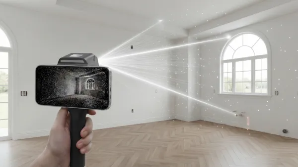
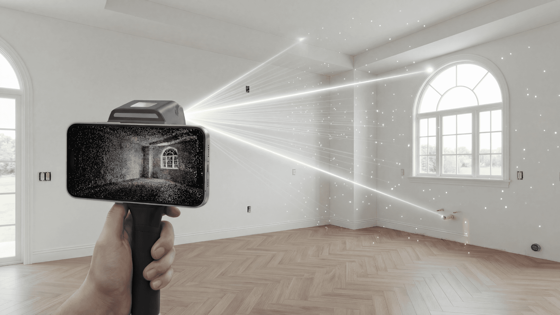
Handheld Lidar
Handheld Lidar
Handheld Lidar
One Walk. One Scan.
Built for Real Job Sites.
No complex setup.
No markers.
No technical training required.
Capture a full room in minutes with a lightweight handheld LiDAR device designed for everyday site work.
Workflow
Workflow
Device. Dimensions.
Drafting. Done.
Speed up your workflow from a physical space to a production-ready file. We handle the complexity of site surveying so you can focus on the art of design.
"AI-powered workflows reduced error rate by 80% in daily operations"
InovaMetrics combines LiDAR-based capture with AI-driven algorithms to translate real spaces into structured spatial data—built for professional design and build workflows.
Impact :
Full-room capture in minutes
AI-structured geometry output
Reduced manual measurement work
"Live scan preview during capture"
Scan and validate spatial completeness in real time—before leaving the site.
Impact :
Live spatial reconstruction
Fewer missed dimensions
Less back-and-forth site checkinging or ambiguous details
"Explore the captured space before leaving the site"
After scanning, you can move through the space virtually to inspect corners, connections, and constraints, and confirm key dimensions visually.
Impact :
Reduced site revisits by 25–50%
Faster issue detection
More confidence before drafting
"Review, adjust, and export with confidence"
A clean interface lets you compare scan data with CAD references, make final adjustments, and export more reliable CAD outputs.
Impact :
20–40% fewer CAD revisions after initial delivery
2x faster CAD-ready preparation time
More predictable output quality
"AI-powered workflows reduced error rate by 80% in daily operations"
InovaMetrics combines LiDAR-based capture with AI-driven algorithms to translate real spaces into structured spatial data—built for professional design and build workflows.
Impact :
Full-room capture in minutes
AI-structured geometry output
Reduced manual measurement work
"Live scan preview during capture"
Scan and validate spatial completeness in real time—before leaving the site.
Impact :
Live spatial reconstruction
Fewer missed dimensions
Less back-and-forth site checkinging or ambiguous details
"Explore the captured space before leaving the site"
After scanning, you can move through the space virtually to inspect corners, connections, and constraints, and confirm key dimensions visually.
Impact :
Reduced site revisits by 25–50%
Faster issue detection
More confidence before drafting
"Review, adjust, and export with confidence"
A clean interface lets you compare scan data with CAD references, make final adjustments, and export more reliable CAD outputs.
Impact :
20–40% fewer CAD revisions after initial delivery
2x faster CAD-ready preparation time
More predictable output quality
Step 1
Device
Start with the professional LiDAR handheld.
One walk, one scan.
Speed up your workflow by capturing every detail with precise 1:1 digital data.
Analyzing current workflow..
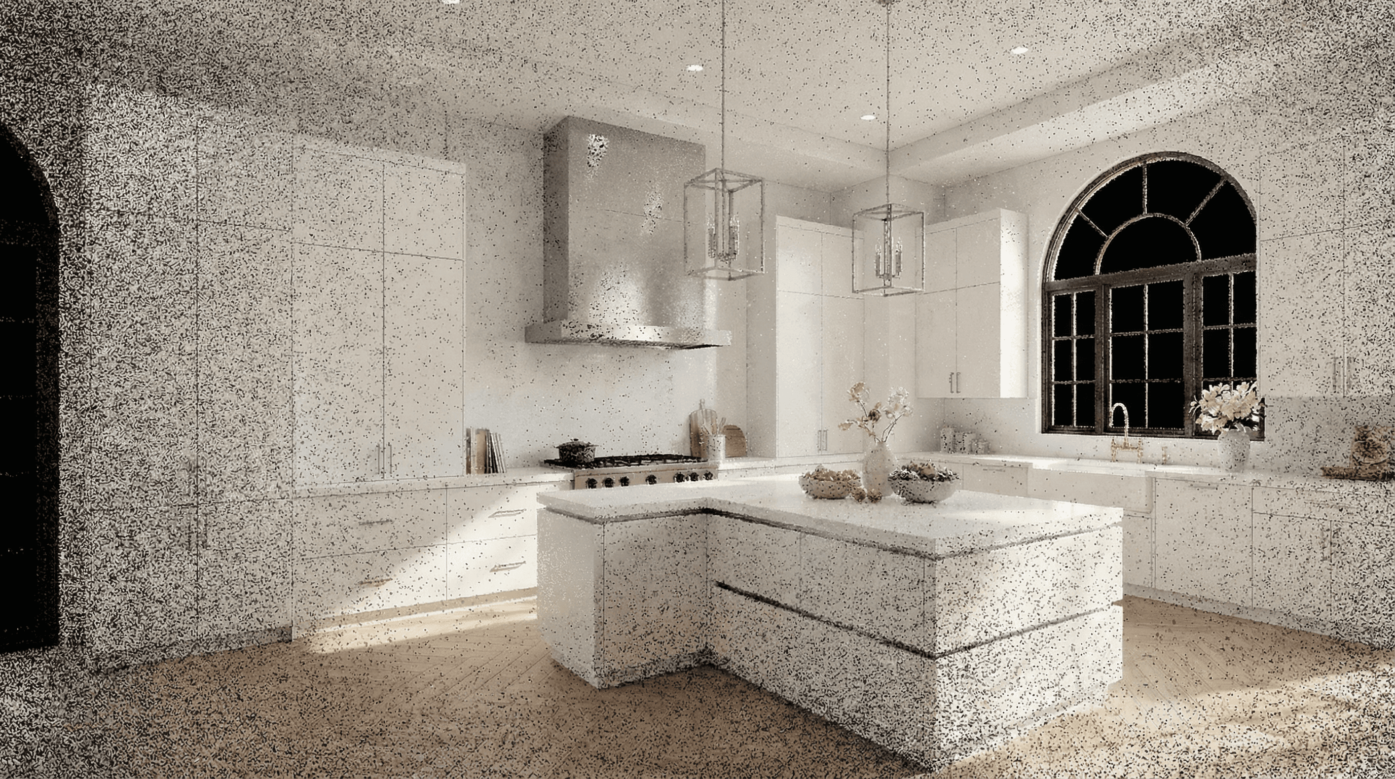
Spatial Capture
Real-Time Model
Detail Preview
Data Alignment
Export
Analyzing current workflow..
Spatial Capture
Real-Time Model
Detail Preview
Data Alignment
Export
Analyzing current workflow..
Spatial Capture
Real-Time Model
Detail Preview
Data Alignment
Export
Step 2
Dimensions
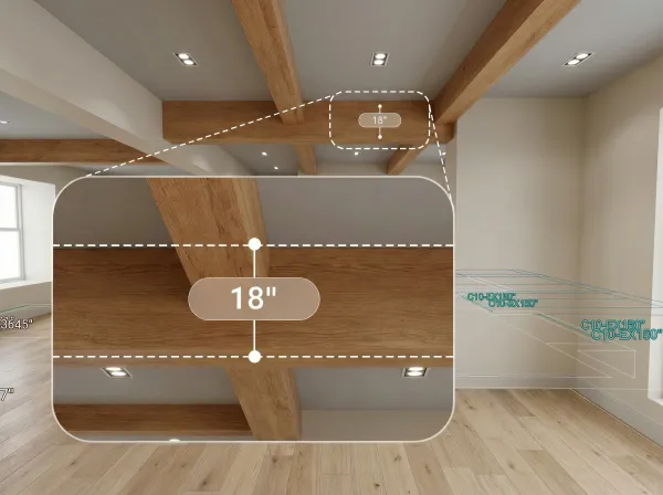
Our engine interprets raw data into spatial logic. Automatically recognize walls and openings, providing the precision you need to design with confidence.
- Wall Detection ✓Opening Recognition ✓Auto Dimension ✓
Temporary Objects Removed ✓Accuracy: ± 1/2" - Wall Detection ✓Opening Recognition ✓Auto Dimension ✓
Temporary Objects Removed ✓Accuracy: ± 1/2"
- Wall Detection ✓Opening Recognition ✓Auto Dimension ✓
Temporary Objects Removed ✓Accuracy: ± 1/2" - Wall Detection ✓Opening Recognition ✓Auto Dimension ✓
Temporary Objects Removed ✓Accuracy: ± 1/2"
- Wall Detection ✓Opening Recognition ✓Auto Dimension ✓
Temporary Objects Removed ✓Accuracy: ± 1/2" - Wall Detection ✓Opening Recognition ✓Auto Dimension ✓
Temporary Objects Removed ✓Accuracy: ± 1/2"
Step 3
Drafting
Skip the manual tracing.
We generate production-ready DWG and SKP files directly from your field data, tailored for your design environment.
Our solution


Output
Our solution
Output
Our solution
Output
Step 4
Done
From site survey to final presentation.
Your project is ready for build.
Speed up your workflow and eliminate the risk of costly site revisits.
Site Measurement -80%
On-site labor time
Design Process -70%
Drafting time
Team co-operation -50%
Revision cycles
Site Measurement -80%
On-site labor time
Design Process -70%
Drafting time
Team co-operation -50%
Revision cycles
Site Measurement -80%
On-site labor time
Design Process -70%
Drafting time
Team co-operation -50%
Revision cycles
Handheld Lidar
Handheld Lidar
Handheld Lidar
More Services. More Updates.
Continuously Evolving.
New features rolling out regularly.
Expanded tools across the workflow.
Built to grow with your business.
Our platform keeps improving - delivering smarter tools and deeper integration over time.